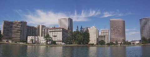
The City of Oakland will soon begin a view corridor study in order to preserve scenic views of downtown. This is occurring at the direction of the City Council in July, 2009. During the downtown rezoning at that time, there was wide spread community support for a view corridor study. Much of that support came from a growing awareness that views of downtown from Lake Merritt were being lost behind the slow but persistent development of high-rise buildings at the edge of Lake Merritt. This was especially true for views of City Hall and the Tribune Tower which could easily be lost forever with the addition of only two or three more high-rises.
Even though view corridors are new to Oakland, they are well known elsewhere. And, because a number of cities, such as Cincinnati,OH (whose study has a number of sections), Austin, TX, and even Sacramento, have conducted them, Oakland won’t need to start from scratch. I think the study that Seattle did for the Space Needle is pretty interesting, too. A review of these studies of other cities is helpful to quickly understand what a view corridor study entails and how such a study is undertaken. Some of the views at Lake Merritt can be seen on Flickr
There are some interesting themes across the studies that are worth mentioning. First, cities often start view studies with a common sense of agreement among constituencies – government, preservation, and development - that preserving views of historic buildings, architecturally-significant structures, and natural features, is worthwhile and has tangible positive benefits for a city. At the same time, the studies typically demonstrate an explicit understanding of the need to strike a balance between view preservation and the development goals of a city.
A second striking feature is how seriously cities approached the task of conducting a view corridor study. Each undertook open processes to ensure that objective criteria were used. From there, they identified and analyzed views, cataloguing the strengths and weakness of specific views, and then producing final reports and recommendations. The use of such objective standards and a public process resulted in high-quality and credible policy and implementation documents. There is a lot that Oakland can learn from the efforts of other cities in this regard.
For example, cities typically conducted an inventory of all possible scenic views with no attempt to eliminate views at the beginning. Views were later evaluated using a set of criteria such as: quality of the object being viewed (historic, or otherwise); the characteristics of the view point (pedestrian oriented, or otherwise); the amenities available at view point (benches, pedestrian, or otherwise); whether a view is seasonal, or year-round (or otherwise), etc. These characteristics were assigned values and final judgments were made whether or not to preserve specific views.
In practice, initial inventories collected baseline information on many more views than were finally selected. For example, Cincinnati began with 93 views, of which 48 were given high ratings. (Note: Cincinnati is older and larger than Oakland, and the topography is hilly with a large river running next to downtown. These features in Cincinnati create views not available within Oakland’s topography.) Likewise, the study for the Space Needle in Seattle began with an initial inventory of 86 separate views. That city eventually designated 10 views for preservation.
We should expect Oakland’s study to unfold in a similar manner, beginning with an inventory of all possible views from Lakeshore Avenue and perhaps other areas at the perimeter of Lake Merritt. While some of the most dramatic views of City Hall and the Tribune Tower are from the park land and walkways along Lakeshore Avenue, there might be other less obvious views to consider. As to finishing the study, no timeline is available yet for the Lake Merritt portion. CALM has suggested that the study might be concluded and forwarded to the City Council for final adoption on or before July, 2010. Keeping to this time table will fulfill the City Council's wish in 2009 to finish the view corridor study in one year.
Showing posts with label "lake merritt" "rezoning" "central business district" "Oakland" "Oakland City Council" "Coalition of Advocates for Lake Merritt" "CALM". Show all posts
Showing posts with label "lake merritt" "rezoning" "central business district" "Oakland" "Oakland City Council" "Coalition of Advocates for Lake Merritt" "CALM". Show all posts
Tuesday, January 19, 2010
Saturday, June 7, 2008
CALM
The Coalition of Advocates for Lake Merritt (CALM) is an all-volunteer group of Oakland residents, professionals, and activists focused on protecting and improving the environs at Lake Merritt and preserving its surrounding parks and historic neighborhoods. CALM has been active in Oakland since 2001 when the City of Oakland offered to sell park land on 12th Street at the south end of Lake Merritt for private development. Cathedral
As an alternative to selling park land, CALM submitted a community-based proposal to remove traffic lanes and reclaim park land at 12th Street. The proposal was eventually accepted by the City and became part of the Lake Merritt Master Plan. Lake Merritt Master Plan Soon after, Measure DD was placed on the ballot by the Oakland City Council and included the CALM plan. Measure DD passed by a margin of 80% - 20% in 2002 and has already funded numerous restoration and reclaimation projects throughout Oakland, and will reclaim park land at Lake Merritt and reconnect it to the Lake. Measure DD
This blog deals with the City of Oakland's 2008 initiative to rezone the Central Business District (CBD). Working within this rezoning process, CALM's membership and supporters are providing specific proposals to preserve the historic buildings, social fabric, park land, and open space of the Gold Coast neighborhood of the CBD. CBD Rezoning Map
Subscribe to:
Posts (Atom)